The Pacific Coast Intermodal Port
This site provides publicly available information about the proposed Intermodal Port project being planned by the Port of Coos Bay, Oregon.
It is designed to provide facts about the project rather than promotional information by project proponents.
The Pacific Coast Intermodal Port Project has three components:
- Expansion of Coos Bay’s Federal Navigation Channel to accommodate ships 1100 ft long with a draft of 49 ft.
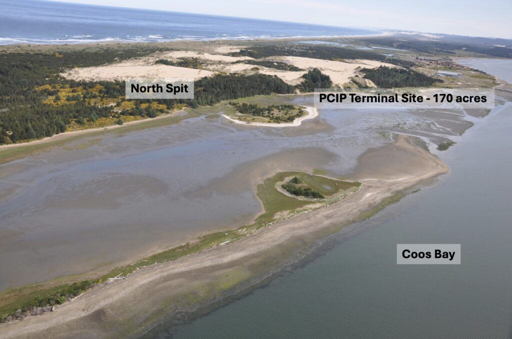
- A new container shipping terminal on the tsunami prone sand spit on the north side of Coos Bay capable of handling two million twenty-foot containers per year.
- Upgrades to the 100+ mile railroad, built in 1916, linking Coos Bay with Eugene to allow passage of 12 mile+ long trains each day, six in and six out.
The Pacific Coast Intermodal Port Business Plan
How much will it cost?
The Pacific Coast Intermodal Project is shaping up to be an extremely costly gamble, with estimates soaring as high as $4.36 billion — far beyond initial figures. Despite receiving more than $100 million in public planning funds and new state bonding, supporters press ahead, calling Coos Bay “the Appalachia of Oregon” in a bid to justify the investment. Critics see it as an expensive bet with uncertain returns for a struggling community.
Who will pay for it?
So far, taxpayers are footing most of it — with over $160 million in state funds and $54 million in federal grants committed — while NorthPoint Development has pledged to contribute but won’t disclose how much. The Port has failed to secure full federal funding in recent years after being rated as lacking the capacity to carry out the project cost-effectively.
| Item | Cost |
|---|---|
| Design & Permitting Year-1 | $70,722,000 |
| Design & Permitting Year-2 | $30,000,000 |
| Rail Segment 1 | $274,796,000 |
| Rail Segment 2 | $1,019,922,000 |
| Container Terminal | $1,254,025,000 |
| Eugene Railyard | $104,489,000 |
| Navigation Channel | $551,368,000 |
| Sub-Total | $3,305,322,000 |
| Interest During Construction | $182,731,000 |
| Sub-Total | $3,488,053,000 |
| Contingency (25%) | $872,013,000 |
| Total Costs | $4,360,066,000 |
Note: IDC calculated at the FY24 federal discount rate of 2.75%
Total Costs: $4,360,066,000
Coos Bay Section 204(f)/408 Report to the US Army Corps of Engineers. Economics Appendix – May 2024
Plans to Enlarge Coos Bay’s Federal Navigation Channel
Dredging plans
The proposal would deepen Coos Bay’s Federal Navigation Channel by 9 feet, widen it by 150 feet, and create two turning basins—one stretching nearly bank-to-bank between the North Spit and Empire, near historic Coos Indian village sites. This three-year project would remove over 20 million cubic yards of sand and rock, enough to fill Autzen Stadium seven times. In many areas, soft sediment that supports crabs and clams would be replaced with bare rock. Within seven years, another 12 million cubic yards of sand is expected to slump into the channel, destroying shallow eelgrass habitat.
The role of the Army Corps of Engineers
The U.S. Army Corps of Engineers (USACE) must decide if this expansion is economically justified and environmentally acceptable before granting a permit. Approval would mean the federal government takes on the ongoing maintenance of a project with major, long-term environmental consequences. The Port of Coos Bay’s 2024 permit request and studies are available for public review on the port’s website.
Where would they put the dredge spoils?
Most of the material would be dumped in the ocean, since historic bay disposal sites are no longer used. Two new sites are proposed: a 2.3-square-mile offshore site near Sunset Beach for rock and sand, and a 1,000-acre nearshore site north of the jetty for sand only. The nearshore site could be used only in calm weather, as it’s too close to shore for safe access during rough conditions.
Plans for the Coos Bay terminal
The Container Shipping Industry
West coast container port news
Impacts on the Coos Bay Community
The Empire District
Empire residents are concerned that the proposed terminal may cause pollution, harm wildlife, strain infrastructure, lower property values, and disrupt neighborhood character.
Noise, Air and Light pollution
The proposed PCIP terminal would generate continuous noise, diesel pollution, and disruptive lighting from around-the-clock ship and train operations, posing health and environmental risks to workers and nearby residents.
Confederated Tribes of the Coos, Lower Umpqua and Siuslaw Indians Hollering Place
The Confederated Tribes of the Coos, Lower Umpqua, and Siuslaw Indians have long lived along Coos Bay, where the Hollering Place served as a vital historic travel and crossing site near the proposed terminal.
Impacts to recreational use of Coos Bay
Dredging for the terminal would destroy vital estuarine habitats, alter salinity and water flow, harm fisheries and shellfish production, and disrupt recreational use of Coos Bay.
The Rail Line to Eugene and Beyond
What is planned for the rail line
The Port of Coos Bay plans to spend $1.4 billion upgrading its 130-mile rail line to move 2 million containers annually between Coos Bay and Eugene, requiring twelve 1.7-mile-long trains per workday. Public costs have already exceeded $100 million, with more federal grants awarded despite limited public information on the project.
Along the Line
The route crosses mountains, lakes, 121 bridges, and nine tunnels, all of which would need costly upgrades for double-stacked containers and increased train traffic. Communities like Reedsport face significant impacts, with up to twelve 1.7+ mile trains passing daily.
In Eugene
North and South from Eugene
Most freight is expected to travel north to Portland before heading east, avoiding the longer southern route over Donner Pass. This routing still funnels additional heavy rail traffic through Oregon’s busiest rail corridors.
Climate Consequences
Lorem ipsum dolor sit amet, consectetur adipiscing elit. Ut elit tellus, luctus nec ullamcorper mattis, pulvinar dapibus leo.
Ecological Consequences
Lorem ipsum dolor sit amet, consectetur adipiscing elit. Ut elit tellus, luctus nec ullamcorper mattis, pulvinar dapibus leo.
How to get involved
November 19, 6:30 - 8 PM
The League of Women Voters of Coos County is holding an informational presentation about the international container shipping industry at the Egyptian Theater in Coos Bay.
November 21, 12 – 1:15 PM
The Eugene City Club has a presentation by the promoters of the PCIP project, “The Pacific Coast Intermodal Port Project: Its Impact on the Region and Eugene”.
Sign up for our mailing list to stay up-to-date on the latest news and information surrounding the PCIP and learn about actions you can take.